The Firth of Forth is geographically and strategically at the heart of Scotland. It has been, and remains, an important seaway linking the Central Belt with the rest of the world, and has been a major point of entry to the country throughout history. The evidence of the strategic importance of the firth is present in countless features all around the Inner Forth, from the medieval battle site of Stirling Bridge to the Victorian landmark of the Forth Bridge, as well as many much older sites.
At the same time, the Inner Forth is home to some of Scotland’s most important natural heritage sites. The Forth valley and adjacent hills illustrate the geology and ancient past of the region and have permitted the development of the rich habitats found in the area today. The landscape of the Inner Forth is host to nationally and internationally important flora and fauna, both coastal and land-based.
The presence of these valued habitats alongside active industrial centres and the depth of the cultural landscape, all within reach of large sections of Scotland’s population, is what make the Inner Forth a unique and valuable landscape resource.
The Inner Forth Landscape Initiative aimed to protect, enhance and celebrate the area’s rich cultural and natural heritage, and to enable local people and visitors to understand the importance of the Inner Forth to the environment and cultural development of Scotland. Inner Forth Futures plans to continue that work.
The estuarine landscape is a dynamic one, continually changing. As the tides and seasons change, the character becomes transformed. On a generational timeframe, new settlements, land uses and industries have emerged. And on a geological timeframe, glaciations, sedimentation and changes in geomorphology have created dramatic alterations in sea level and topography. These changes will continue, particularly under the predicted impacts of climate change.
Formation of the Landscape The Firth of Forth forms part of an ancient rift-valley (known as the Midland Valley of Scotland), made up of an area of subsided land between two major fault-lines, the Highland Boundary to the north and the Southern Upland to the south, as well as being fissured by many other fault lines, including the Ochils Fault (see Sketch 1). The geology of the Inner Forth area is formed of sedimentary material laid down in the coal swamps and lakes in the Carboniferous period (370-300million years ago). These rocks have left the area rich in coal, limestone and sandstone.
Sketch 1: The Ochils Fault occured during the Devonian Age
During the last Ice Age, when the whole of Scotland was covered in thick ice sheets, a major glacier flowed through the lowland area created to the south of the Ochils Fault. The topography of the Firth of Forth area was extensively modified by the advance and retreat of these ice sheets, leaving the characteristic U-shaped valleys and smaller scale ‘crag and tail’ features such as at Castle Rock, on which Stirling Castle stands.
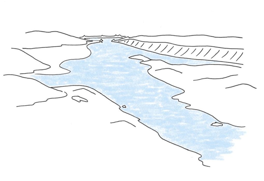
When the ice melted – between 10,000 and 6,000 years ago – the warmer climate meant that the sea level was high, considerably higher than today, at +12-14m. The Forth Valley was inundated as far inland as Aberfoyle and much of the Inner Forth area was covered in water (see Sketch 2). Between Bo’ness and Stirling, the basin left by the glacier would have been up to 14-15 km across. The coastal erosion created wave cut platforms and coastal cliffs. The marine deposits from this era extend over much of the study area, and these silt-rich carse clays formed the basis of soils and mudflats of today.
Sketch 2: Maximum post-glacial sea inundation
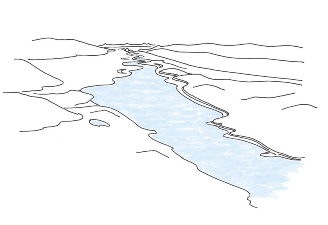
As the water levels receded, the beaches that had formed around the Forth were left high and dry, and form the characteristic ‘raised beaches’ that are seen all round the Inner Forth today. The sea within the Forth Basin was reduced to a broad estuarine river flowing in sweeping meanders across a broad floodplain (see Sketch 3), while in the channel downstream, the estuary remains broad, with narrow raised beaches on either side. Peat developed on the wetlands on the valley floors, forming extensive bogs and mosses across parts of the Inner Forth and Carse of Forth areas.
Sketch 3: A meandering river
The first human settlers would have arrived by boat or across land from other parts of the UK, and been nomadic hunter-gatherers, exploiting what food sources were available at different times of year. The first evidence of man on the landscape around the Forth appears around 7,000 years ago, in the Mesolithic Period (c.6,000 BC to 4,000 BC). Their nomadic lifestyle left few visible traces of their existence, although dugout canoes have been found in the lower carse clays and huge shell middens found near Bo’ness. The Forth-Clyde isthmus was identified as being of critical strategic importance during the Roman period, allowing the Romans to establish a defensible frontier and a permanent military presence. The Antonine Wall was built across the Forth-Clyde isthmus on the orders of the Emperor Antoninus Pius (reigned 138-161 AD), and survived as the north-west frontier of the Roman Empire for a generation before being abandoned in the AD 160s in favour of a return to Hadrian’s Wall. The Antonine Wall was the most strategically advanced and most heavily-guarded frontier ever constructed in the Roman world and is included in the ‘Frontiers of the Roman Empire’ transnational World Heritage Site [1]. Cutting across Scotland at its narrowest point, the Antonine Wall ran for 60km from the Firth of Forth, along the top of the raised beach scarp between Bo’ness and Falkirk, westwards to Old Kilpatrick on the Clyde. The remains of the Antonine Wall can be seen today in the landscape within the Kinneil Estate and on the raised beach scarp between Bo’ness and Polmont.
The foundation of burghs in the 12th and 13th centuries and their associated markets and industries, led to the growth of settlements such as Linlithgow, Clackmannan and Stirling and some of the lesser settlements such as Kincardine and Airth. Each burgh had an overseas trade link and a defined landward area. Highly organized vessel ports were established along the coast, such as the royal dockyard for the Stewart Kings at Airth. Some ports were linked to settlements further inland, such as the port for Linlithgow at Blackness. The high concentration of burghs along the Forth shores reflected the prospect of revenue from trade with Europe. At the same time, monasteries were founded in the area (Cambuskenneth and Culross), and took advantage of the natural resources and productive agricultural land around the area.
The Inner Forth area was the setting for the early Scottish Wars of Independence, with the Battle of Stirling Bridge in 1297 and the Battle of Bannockburn in 1314. The flat landscape of the Forth, together with the strategic bridging point at Stirling below the castle would have been important factors in the location of the battlefields. The River Forth itself played a role in the fate of the fleeing soldiers, many of whom died trying to cross the river, or climb up its muddy banks. Old Stirling Bridge marking the western edge of our scheme area is a Scheduled Monument that still stands over the river in Stirling. The putative site of the Battle of Bannockburn is preserved as open space today.
[1] Historic Scotland (no date), The Antonine Wall, Frontiers of the Roman Empire, http://www.antoninewall.org/ [Accessed 16 Oct 2013]
For the Forth and its surroundings, the 13th to 17th centuries was a period of prosperity, with the development of early industries such as pottery production, mining for coal, salt panning and the production of lime for agricultural improvement of the soils. The coastal location was important for export, and the demand for exported industry products fuelled the prosperity of the area. The early origins of salt panning can be heard in local place names such as Kennetpans and Grangepans, and also contributed to the history of settlement and the development of wealthy estates such as at Valleyfield. Charlestown and nearby Limekilns were centres of iron and coal mining, and lime production, and both settlements were developed by Lord Elgin to exploit the resources of his estates. The names of both these villages reflect this history. A medieval pottery production centre was established at Throsk, producing green glazed tableware.
Many significant houses and estates were established, particularly during the 17th and 18th centuries, with the wealth that was gathered through the proceeds of industry such as mining, ironworks and salt panning. 'Policy' landscapes are regular and important features in the landscape (e.g. Dunmore Park and the Pineapple, Valleyfield Woodland Park, Kinneil House and estate). Many of these sites have connections to notable architects and landscape designers including Sir William Bruce, William and Robert Adam and Humphrey Repton. The influence of the trading links can be seen for example in the famous red pantiles in Culross, thought to be a direct result of collier ships returning to Culross with Dutch tiles as ballast.
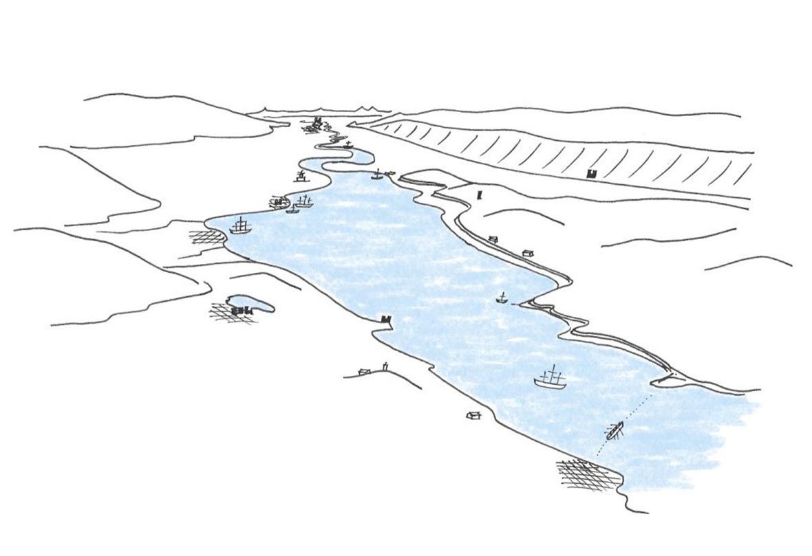
Following the Act of Union of 1707 there was increased change. Agricultural improvements, industrialization, urban development and population growth all accelerated to alter the landscape (see Sketch 4). Traditional runrig agriculture disappeared and field sizes and agricultural intensification grew. The fertile soil meant that agricultural land was in demand. As a result, peatland was drained and cut, and particularly significant for the Forth, land was reclaimed from the river, notably around Airth, Skinflats and Clackmannan using water pumping systems similar to the Dutch polders.
Sketch 4: 18th Century use of the river and historic ports
In parallel with the Clyde, the Forth was at the heart of the birth of the Scottish industrial landscape: brick chimneys, aqueducts, colliery villages, docks and harbours survive to this day along the Forth.
The presence of easily accessible coal seams alongside valuable resources such as lime and iron ore, as well as settlements and transport routes enabled the early development of industries such as salt and lime production, initially led by the monasteries at Culross. Demand for coal led to planned villages such as those at Dunmore and Kennet to house local miners and their families, and to the development of significant innovations such as James’ Watt’s improvements of the steam engine, which started at Kinneil. Most recently, large scale industrial mines were housed at Valleyfield, Polmaise and Kinneil, the last of which closed in 1987. Important reminders of this mining heritage are found in the annual children’s fair and colliery bands of Bo’ness, as well as mining memorials.
Lime from places like Charlestown was used as mortar in the construction of Edinburgh's new town, and as a fertiliser to neutralise acidic soils.
With the new developments in industry, transport became increasingly important. Alloa was at that time the main port inland along the Forth, and was the closest to Glasgow. In 1790, the Forth and Clyde Canal was opened, giving direct access between the port of Grangemouth and Glasgow, followed in 1822 by the Union Canal, linking the area to Edinburgh. A significant landscape influence has been the railways, which first crossed the area in the 1840s. The links of tracks, bridges, viaducts and stations were to have a dramatic and lasting effect on the landscape of the area.
Sketch 4: 18th Century use of the river and historic ports
Land reclamation was accelerated during the 19th and 20th centuries, through drainage of wetlands and mudflats behind raised embankments, or more recently the deposition of materials such as ash from industry. Many of these areas were reclaimed for the purpose of agriculture, but have since been taken over by industrial land uses. Land reclamation also involved riverbank or shore defences against natural erosion and has resulted in rectilinear shorelines, and the straightening or formalising of meanders in the river further upstream. Peat extraction reduced areas of peat to small pockets, and continues today on Letham Moss. Today it is estimated that approximately 45% of the inter-tidal area of the Inner Forth has been converted to land for industry and agriculture over the last 400 years (Stewart, 2013) [2].
The petrochemical industry was started up in 1910 with works at Uphall for refining shale oil, but moved to Grangemouth in 1924 with a dedicated refinery built and later expanded upon reclaimed land, particularly after 1975 with the introduction of North Sea oil to the site. Kincardine Power Station (now gone) was located on top of deep mines near Kincardine, and was linked to the east with a rail line. The ash produced from Kincardine Power Station was dumped on the coast to the east of Kincardine, forming a platform of ‘reclaimed’ land on which Longannet Power Station (closed in 2016 and demolished in 2021) once stood. In turn, ash from Longannet was dumped at Preston Island to form a large reclaimed area near Valleyfield.
[2] Smout, T C & Stewart, M 2012 The Firth of Forth: an environmental history. Birlinn.
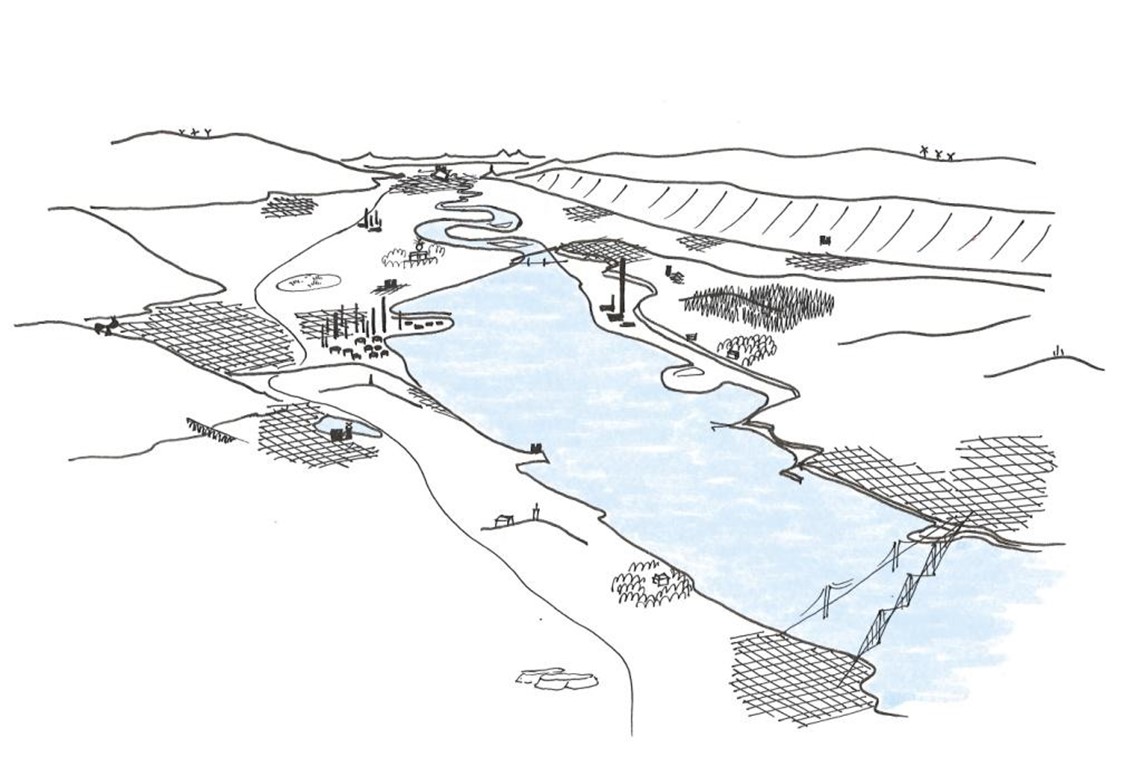
Today, the landscape of the Inner Forth is still dominated by open agricultural land, although there is a very strong presence of settlements and industry (see Sketch 5). The land capability for agriculture is generally of a high order, classes 2 and 3, with pockets of class 1 on the lighter soils, particularly on raised beaches and other alluvial deposits. Agriculture remains a mixture of arable, ley and pasture land, but is highly mechanised and intensive in nature, with large rectilinear fields often with degraded field boundaries of post and wire fences with patchy hedges or walls.
Sketch 5: Today's busy landscape
In order to maximise agricultural productivity, woodland and forestry cover has been kept to a minimum. Woodlands and forests are mostly associated with the designed landscapes of the main estates, although the natural topography of coastal bluffs, scarps and incised river valleys has preserved other small but significant pockets of woodlands, which the scheme will help conserve.
Today, despite being such a highly modified and fragmented ecological landscape, the area remains of significant importance for its natural heritage. The floodplain exhibits a range of outstanding riverine features that include tidal banks, rare saltmarsh habitat and extensive areas of mudflats. The mudflats provide a rich source of food such as worms and shellfish that are incredibly important for wildfowl and wading birds. Much of the Inner Forth estuary is designated under the European Birds Directive, amended by the Conservation (Natural Habitats, &c.) (EU Exit) (Scotland) (Amendment) Regulations 2019, as the Firth of Forth Special Protection Area and nationally, as a Site of Special Scientific Interest (SSSI), providing a valuable habitat for internationally important wintering and migratory waterfowl.
The high proportion of vacant and derelict land left from the remains of past industries and waste is providing new opportunities for wildlife to flourish as well as valuable greenspace for local communities.
Settlements have expanded greatly from their historic cores, to include the more recent suburban housing estates. Light industrial business parks have sprung up adjacent to many settlements, and often settlements have coalesced with others nearby, creating continuous settled areas with industrial sectors.
Heavy industry is a prominent feature of the Inner Forth area, with major petrochemical works at Grangemouth, the works at Cowie and Alloa forming tall vertical structures in an otherwise largely horizontal landscape. These clusters of tall silver chimneys and their smoke plumes can be seen for many miles and form landmarks in most views around the area. Although the Longannet chimney was demolished in 2021, parts of the complex remain, and this site, the old Kincardine Power Station site and the restored ash lagoons at Valleyfield are prominent landscape features. Power lines are also prominent features, with a network of small cables and huge pylons crossing the valley including the Beauly to Denny power line that crosses the area near Stirling.
Nested between two national and international tourist destinations (the City of Edinburgh and Loch Lomond & the Trossachs National Park), the Forth Valley mainly attracts visitors from within Scotland (VisitScotland, 2021) [3]. The Inner Forth’s heritage potential is underutilised (Webster, 2020) [4] and its tourism offer is often overlooked, with the exception of a small number ofwell-known and heavily visited heritage attractions (e.g. Stirling Castle, the Kelpies, Culross, the Forth Bridges World Heritage Site). The rise of film tourism, notably with the series “Outlander”, has given greater visibility to some attractions which do not have the capacity to welcome large volume of visitors (e.g. Culross, Blackness Castle). These honeypot sites therefore suffer from the resulting social and environmental pressures, and the economic benefits of tourism often fail to spread around the whole area.
[4] Webster, 2020: Pride in Place. The RSA Heritage Index 2020
The Inner Forth is a dynamic working estuary, continually changing and evolving. It remains a critically important area for Scotland’s economy, particularly the oil and gas industry, and is a major residential area due to its proximity to Edinburgh and Glasgow. There is continued pressure from industry and business to expand industrial development and housing within the area and this in turn can create additional disturbance to wildlife. Transport links are also likely to continue to grow across the area, and will have to cater for increasingly mobile populations. As a result of these changes, the importance of the area for wildlife, particularly birds, will continue to come under increased pressure
The predicted impacts of climate change, including increased storms, flooding and sea level rise are likely to have a very significant impact on this low-lying landscape. The Inner Forth is one of the areas most at risk of flooding in Scotland (National Flood Risk Assessment, 2018) [5]. This could have a significant effect on the coastal and riverside flats, potentially making them uncultivable in the future and putting communities at risk. Measures to adapt to this change could lead to the development of hard engineering solutions such as higher seawalls but also offers new opportunities to reimagine flood defences including greater use of natural flood management solutions such as wetland creation and/or managed realignment that may bring additional benefits in terms of nature and tourism.
Tourism nationally and internationally is becoming increasingly experiential, with visitors looking for “immersion”, authenticity and unique experiences. Investments at regional and national levels are also supporting modal shifts from passenger cars to bicycles, which extends to visitors’ travel behaviours. Besides, the COVID-19 pandemic is still having a significant impact on the hospitality and tourism sectors, with staff shortages, economic loss and the closure of businesses. However, it is worth noting that the pandemic has also led to an increased interest in staycations and local tourism, and a need to reconnect with nature. Within the Inner Forth, responding to these trends can help with the economic resilience of the area by spreading the tourism flow throughout the landscape in a sustainable manner and reduce pressures at honeypot sites without increasing social or environmental pressures elsewhere.The potential to do this is aided by the Forth and Clyde and Union Canals and the John Muir Way providing linear routes to help visitors move around the landscape.